
 7339
7339
Resume Skills and Keywords for Cartographer
Cartographers research, develop, create, and disseminate digital and traditional maps, charts, spreadsheets, and diagrams for both public and private sector clients.
Skills required for a Cartographer's role
- GIS Design
- Digital Drafting
- ESRI Suite RDBMS and GPS data collection
- System Applications and Products in data processing
- Public Land Surveying
- Data Analysis
- Spatial Data Cartography
- Analytical Ability
- Problem-Solving Skills
- Adobe Photoshop
What recruiters look for in a Cartographer professional’s resume:
- Strong capabilities in researching and designing maps, graphics, illustrations and layouts
- Ability to clearly articulate and communicate information through the use of colour, symbols and style
- Skills in compiling and producing graphs on computers for specialist and general users
What can make your Cartographer resume stand out:
A strong summary that demonstrates your skills, experience and background in cartography
- Highly organized and motivated individual with a recent course in computer mapping and remote sensing. Strong technical background with extensive work in GIS software, cartography and image analysis. Voted as "Best Employee of the Year".
Targeted job description
- Design, maintain and manipulate geographical information (GI) databases
- Work with geographical information systems (GIS) to see, model and analyze landscape features
- Use desktop publishing packages to edit and formulate information
- Capture, maintain and output digital geographic data
- Generalise map data to allow for a reduction in scale
Related academic background
- B.Tech (Geo-Informatics) ► Anna University, Bangalore 2018
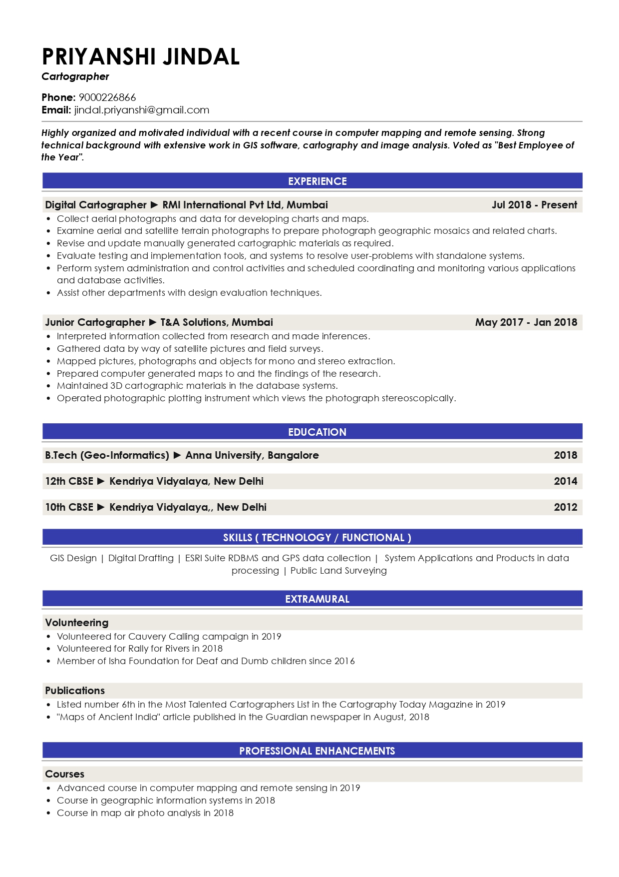
Sample Resume of Cartographer in Text Format
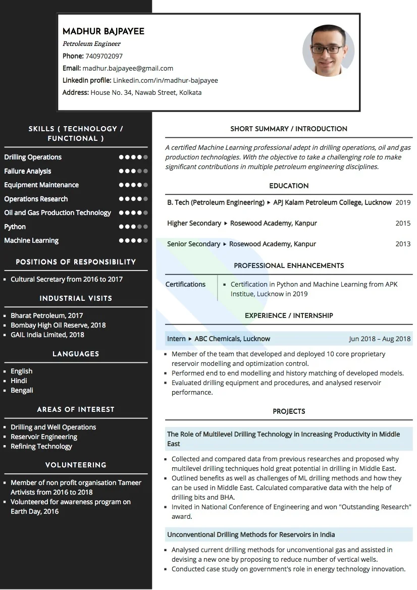
PRIYANSHI JINDAL
Cartographer
9000226866 | jindal.priyanshi@gmail.com
SUMMARY
Highly organized and motivated individual with a recent course in computer mapping and remote sensing. Strong technical background with extensive work in GIS software, cartography, and image analysis. Voted as "Best Employee of the Year".
EXPERIENCE
Digital Cartographer
RMI International Pvt Ltd, Mumbai | Jul 2018 - Present
- Collect aerial photographs and data for developing charts and maps.
- Examine aerial and satellite terrain photographs to prepare photograph geographic mosaics and related charts. Revise and update manually generated cartographic materials as required.
- Evaluate testing and implementation tools, and systems to resolve user-problems with standalone systems. Perform system administration and control activities and scheduled coordinating and monitoring various applications and database activities.
- Assist other departments with design evaluation techniques.
Junior Cartographer
T&A Solutions, Mumbai | May 2017 - Jan 2018
- Interpreted information collected from research and made inferences.
- Gathered data by way of satellite pictures and field surveys.
- Mapped pictures, photographs and objects for mono and stereo extraction.
- Prepared computer-generated maps to and the findings of the research.
- Maintained 3D cartographic materials in the database systems.
- Operated photographic plotting instrument which views the photograph stereoscopically.
EDUCATION
- B.Tech (Geo-Informatics) ► Anna University, Bangalore 2018
- 12th CBSE ► Kendriya Vidyalaya, New Delhi 2014
- 10th CBSE ► Kendriya Vidyalaya, New Delhi 2012
SKILLS ( TECHNOLOGY / FUNCTIONAL )
GIS Design | Digital Drafting | ESRI Suite RDBMS and GPS data collection | System Applications and Products in data processing | Public Land Surveying
EXTRAMURAL
Volunteering
- Volunteered for Cauvery Calling campaign in 2019
- Volunteered for Rally for Rivers in 2018
- Member of Isha Foundation for Deaf and Dumb children since 2016
Publications
- Listed number 6th in the Most Talented Cartographers List in the Cartography Today Magazine in 2019 "Maps of Ancient India" article published in the Guardian newspaper in August, 2018
PROFESSIONAL ENHANCEMENTS
Courses
- Advanced course in computer mapping and remote sensing in 2019
- Course in geographic information systems in 2018
- Course in map air photo analysis in 2018
Awards
- Received "Employee of the Year" award in 2019